The United Kingdom is undertaking reforms in the planning system. Homes and streets from late Victorian and early 20th-century Britain are to be rediscovered and made fit for the 21st century.
The Ministry of Housing, Communities and Local Government, UK, in 2020 published a white paper that outlined geospatial technology and data have an important role to play in the digital planning reform of the country. Similarly, using mapping and associated analytical tools was also one of the recommendations in the report released in February 2022 by the Independent Digital Task Force for Planning.
The Winning Local Planning Authorities
Esri UK organized a competition to find local planning authorities with innovative ideas for how best to use geospatial technology to help modernize the planning process. The competition attracted almost 50 entries. In April 2022, the company announced three winning councils – Nottingham City, Dacorum Borough Council, and South Ayrshire.
Having won the competition, the councils have been working with Esri UK to make the projects a reality, receiving free consultancy and access to GIS (Geographic Information Systems) software. Esri UK has announced the results of three pilot projects. These projects have focused on solving common planning challenges, including improving community engagement, maximizing 3D visualizations, and managing developer contributions more efficiently.
Results of the Pilots
The competition revealed several common planning challenges faced by local authorities, including community engagement, how to maximize the use of 3D visualizations, and opportunities to manage developer contributions more efficiently. Esri UK is also creating a Customer Advisory Board to help grow the best practice use of GIS within planning.
Nottingham City Council’s pilot has proven the value of using 3D visualizations integrated with other existing data to allow constraints and impact assessments to be carried out simultaneously. Dacorum Borough Council’s project has built a prototype tool that visualizes infrastructure and developer contributions secured through Planning Obligations on a map, replacing traditional static spreadsheet data. While South Ayrshire Council’s outcome has been creating a community consultation platform with interactive engagement methods to improve the community and other stakeholder involvement in Local Development Plans.
“The pilots have explored modern digital approaches to some common challenges faced by local planning authorities, all designed to help make the planning process more efficient and easier for everyone,” explained Stephen Croney, Head of Sector for Land, Property, and Planning, Esri UK. “Combining each council’s domain expertise with our team of geospatial experts, the pilots have revealed how geospatial technology available today can help shape the future of the planning process by delivering significant cost and time savings.”
The details of the pilots are as follows:
Nottingham City Council
Nottingham City Council’s project has explored how geospatial technology can help increase the use of 3D visualizations, both internally and with the public. A prototype site assessment tool has been built that combines all relevant spatial data into one 3D environment, including the proposed scheme itself, conservation areas, site allocations, flood risk, and tree cover.
 This has allowed planning teams to simultaneously conduct 3D assessments of various constraints on a site as a visual impact assessment, speeding up the decision-making process.
“The pilot has significantly advanced our 3D development skills, created new 3D data generation and manipulation techniques, and shown how it’s possible to have a 3D environment that can easily integrate with our existing datasets,” explained Mick Dunn, GIS Service Manager, Nottingham City Council. “Overall, the project has proved that 3D planning is possible from any browser at the right performance levels.”
“The benefits are varied, from understanding what a building will look like in situ and trying different view corridors to assess its visual impact to examining master planning issues, flood risk assessments, or potential solar energy sites. The 3D visualizations can also be used to gain public feedback or other parties using images and fly-throughs.”
Dacorum Borough Council
Dacorum Borough Council’s pilot has converted existing text and spreadsheet information into a modern digital mapping environment, improving how infrastructure and developer contributions secured through Planning Obligations are managed and communicated. An interactive map was built that plots the sources of developer contributions S106 and Community Infrastructure Levy (CIL) received and shows where the contributions have been spent.
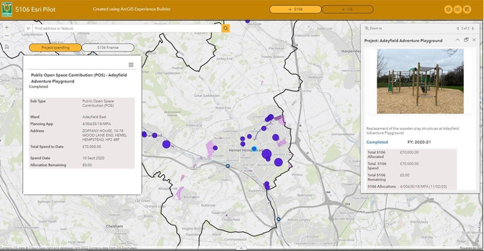
“The pilot has shown the value of using digital maps to visualize and monitor contributions spatially and understand where and how the money is being spent,” commented Councillor Alan Anderson, Portfolio Holder, Planning and Infrastructure at Dacorum Borough Council. “The tool can give a clearer understanding of infrastructure funding received and how it links to infrastructure planned and delivered by presenting the data visually and spatially, using an interactive web experience. Spatially providing this information gives Council officers a powerful asset which can be used for planning, decision making, and monitoring.”
“One of the most obvious findings of the pilot has been how GIS can create interactive experiences with this financial data – particularly the ability to change dull, static spreadsheets into more meaningful, visual data that can be used for multiple purposes,” continued Councillor Anderson. “The value of partnership working has also been demonstrated – Dacorum providing the data and planning process knowledge and Esri UK providing the technical expertise.”
South Ayrshire Council
South Ayrshire Council’s pilot project examined how a consultation platform using interactive engagement methods can help improve community and stakeholder engagement in Local Development Plans to reach better planning outcomes. The collaboration between the council and Esri UK has created a platform designed to keep the public and other parties engaged and informed to strengthen the local planning authority’s relationship with its communities and reach better planning outcomes.
 Built using Esri UK’s community engagement platform ArcGIS Hub, it keeps citizens informed via social media and asks their opinion on what they feel are the main planning issues within their community. The system plots these comments on an interactive map to highlight issues and reveal policy engagement hotspots.
“Esri UK’s flexible suite of digital tools has helped to improve the LDP process and enhance our community and stakeholder engagement, raise our workload capacity, eliminate participation barriers, and drive better outcomes,” said Gordon Wilson, Planning Technician at South Ayrshire Council. “The timing is important as this project to build a planning portal has coincided with the start of the LDP3 process. It’s expected that the hub will start to show how the LDP will plan out and highlight key milestones during the LDP process.”