Fortunately, mass casualty events don’t happen every day. But they still occur far too often. These high-profile incidents present many challenges for law enforcement and public safety personnel, not only at the scene but during the following investigation. Several emerging technologies are helping public safety officials document, process and investigate the incidents and provide answers relevant to who, how, and why.
More importantly, advancements in technology can help prevent or minimize tragic events before they ever happen.
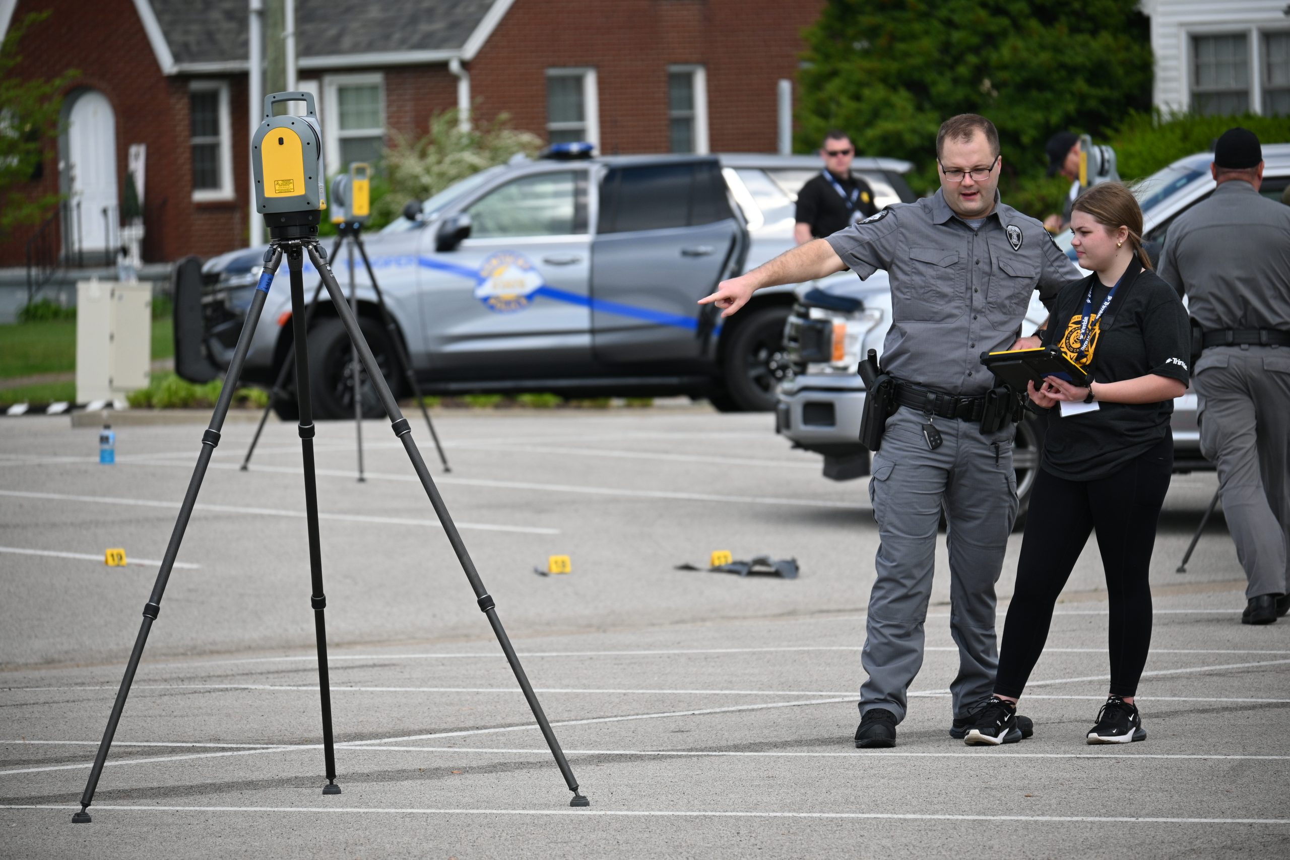
Emergency Responders Conduct Forensic Surveying
Training emergency responders for mass casualty events is extremely difficult because extensive logistics, manpower, and preparation are required to coordinate an effective simulation experience. Resources are limited, and, as a result, training on these types of events does not happen very often.
To be effective, technology deployed to document actual events needs to be intuitive and simple to use. The functionality of purpose-built field software has come a long way since the days when law enforcement and public safety personnel were relegated to using optical total stations and surveyors’ software.
Surveying and mapping were not their main focus, and training on this non-purpose-built field software was time consuming. Retention of knowledge was challenging due to infrequent occurrences of complex mass casualty situations.
While public safety officers use many survey techniques in their mapping, they do not use them often enough to justify a full surveyor license. Their work is often referred to as “forensic mapping” and not “forensic surveying.” Law enforcement officers typically share the same best practices as surveyors, but forensic work is being done by professionals that have other primary job tasks.
Impact of New Location Intelligence Technology
Forensic mapping is a crucial step on the path to establishing a chain of events, although it is not the complete answer in and of itself. To alleviate the surveying experience gap among law enforcement professionals, purpose-built software is tailored to the public safety job to create accurate, defendable maps using techniques that have been time-tested by the survey and geospatial community.
In the last ten years, incredible advancements have been made in field data collection software built with law enforcement and public safety professionals in mind. This software has simplified the gathering of measurement data while still preserving the accuracy and precision of the court-accepted survey workflow. It also gives already-stressed responders one less thing to worry about so that evidence does not get missed or mislabeled.
There have been massive leaps in sensor technology as well. The geospatial sector has used satellites to take measurements for a long time; however, a wider adoption of GNSS instruments in the field of forensics and public safety has only been seen in the last five years or so.
This satellite technology has overwhelmingly reduced time on the scene as investigators no longer need to level a total station tripod, set the total station over a point, observe backsights, and perform other functions that were inherent to the operation of an optical total station. Paired with purpose-built field software, first responders are finding GNSS to be generally simpler and easier to use.
The benefits of GNSS technology don’t stop there. Many mass casualty incidents tend to be spread over a wide area. Especially with aviation incidents, large swaths of land may be involved, necessitating a mapping instrument suited for the task. This is where GNSS technology really shines.
There are several factors to consider to fully leverage the value of GNSS during forensics analysis and simulation training. To map accurately, GNSS instruments require a corrections source that is usually delivered by one of three methods:
- Differential GNSS (Base and Rover)
- Cellular-delivered from a remote base station or base station network
- Satellite-delivered
Each correction method has its advantages and disadvantages; however, many public safety professionals have found satellite services to be quite convenient and accurate. If the sky is visible, satellite-delivered corrections can be delivered to the site.
Cellular connectivity is not required and there is no need to buy a second receiver to act as a base, which cuts down on cost and complexity. All too often, adverse events happen where there’s no cellular coverage, so having a satellite-delivered corrections stream is extremely convenient.
Sensor Technology Provides New Options
Other advancements in sensor technology include the use of Unmanned Aerial Vehicles (UAVs). Capturing images of the scene using cameras, followed by post-processing with photogrammetry has seen wide adoption in the public safety sector, and for good reason. It’s generally an economical approach, and UAVs are easy to operate. A complete aerial view of the scene provides a unique perspective that can be helpful to any investigation.
However, as with most things, there is a tradeoff. When images are processed without survey-grade ground control, there can be large photogrammetric errors. To address this issue, images are coupled with GNSS ground control to produce detailed, realistic maps of large-scale scenes with quantifiable accuracy that stand up to scrutiny in subsequent litigation.
Terrestrial laser scanning technology has also made major strides in the last few years. In the past, after a scanner was placed on the ground, the operator pressed a button, adjusted some settings, moved the scanner around, and repeated until the entire area of interest was covered. There was no way to verify what exactly was gathered in the field or whether the scans would align back at the office.
Recent improvements in mobile computing and software now allow operators to fully visualize real-time data and fit scans together immediately after capture. Investigators know for certain that they gathered enough data on each piece of evidence before it is moved or collected.
The massive strides in this area include full visualization of every point collected while looking at the item being documented. In addition, full in-field registration eliminates the need to drag a laptop or other bulky device into the field. By taking the headaches out of scanning and making it simple and reliable, even inexperienced operators can deliver accurate scanned scenes with limited training.
Focus on Ease of Use
At a recent conference, the Trimble Forensics team placed a Trimble X9 laser scanner equipped with Trimble Perspective field software into the hands of a high-school sophomore and asked her to document the simulated aftermath of a suicide bombing. In less than an hour she was able to produce a fully registered and colorized scene complete with photo annotations of the debris, body parts, and damage to the structure.
Being able to produce a deliverable of a complex scene in under an hour with virtually no training is a testament to what smart technology can bring to the public safety arena. Governments can operate more effectively and efficiently, and with lower cost to the taxpayer. Everybody wins.
These advances in technology also allow commanders of mass-casualty incident response teams to get information quickly to make informed decisions about the next steps. In addition, it gives the investigating agency the ability to provide answers to the public in a timely manner, building trust that this horrific scene is being handled with the utmost urgency and thoroughness. Victims’ families want (and deserve) timely answers, and technology is helping deliver those answers.
Location technology is also helping to blend mapping with other investigative tasks, such as evidence collection and packaging, photography, and note-taking. Evidence collection and documentation can be incredibly laborious, especially in a mass casualty event.
The sheer number of evidence items collected is staggering, and keeping track of what was collected, where it was collected, who collected it, and tracing the chain of custody is time consuming. Most importantly, the process must be verifiable for evidence to be admissible.
The use of simple USB barcode scanners plugged into mapping data collection devices allows the mapping software to become a tool to help catalog evidence. The location, description, and unique code are immediately tied to a location on the scene, not days afterward.
Especially in bomb blasts where evidence can be strewn across a large area, this ability to catalog and location-tie evidence items as they are collected yields a shorter case-closure time and reduces location mix-ups. Under stressful conditions with a high volume of evidence, technology helps law enforcement professionals avoid mistakes that could potentially impact the investigation.
More Effective Facility Security Planning
Location technology enables better pre-planning of building and facility security, resulting in safer events for participants and surrounding communities. Computer Aided Drafting, or CAD, has advanced from simple 2-D line drawings to whole-area capture and analysis.
Instead of looking at a top-down line drawing, planners immerse themselves in the venue environment to pre-plan camera placement, security checkpoint design, and evacuation routes.
Access to 3D models of prospective locations allows security professionals from across the globe to pre-plan a site without ever setting foot in the space. Events such as concerts, sports, and other large gatherings are more secure thanks to advances in visualization.
When coupled with reality capture solutions such as UAVs and laser scanning, security experts can pre-plan like never before. And, in the event of an incident, emergency responders can be briefed and have detailed knowledge of the area before putting themselves in danger.
Documenting facilities such as schools or government buildings has become increasingly important. Remodels and changes to a structure need to be documented for security and response purposes and leaps forward in reality capture technology have made this traditionally time-consuming task much faster and more economical.
Cloud-capable visualization and analysis allow the information to get to the right person at the right place at the right time to determine the appropriate response to an incident.
The advancements in geospatial technology in the realm of public safety are truly staggering compared to ten years ago. Forensic mapping is no longer accomplished using tape measures and mechanical total stations—now UAVs are capturing comprehensive images from the air and using satellites for GNSS, and laser scanners are collecting two million points every second to deliver dense point clouds. The next ten years will continue to make new tools accessible that expand capabilities for forensic analysis and public safety.