
The National Reconnaissance Office (NRO) has announced that it would be investing billions of dollars over the next decade to acquire commercial satellite imagery to meet increasing customer demands with greater capacity than ever before. The contracts, in effect NRO’s largest-ever effort for acquiring Electro-Optical Commercial Layer (EOCL) imagery, were announced on May 25, and was awarded to three companies to Maxar, Planet and BlackSky.
In a statement, the NRO called it the “largest-ever commercial imagery contract effort” representing “a historic expansion of the NRO’s acquisition of commercial imagery to meet increasing customer demands with greater capacity than ever before.”
“The NRO has a long-standing strategy of ‘buy what we can, build what we must’. The diversity offered by our expanding architecture comprised of both commercial and NRO systems increases our resilience and enables an integrated approach to the threats facing our Nation,” said NRO Director Dr. Chris Scolese.
The contracts, which the NRO said were the result of close collaboration with stakeholders from across the defense and intelligence communities, is expected to support the mission needs of NRO’s half-million intelligence, defense, and federal civil agency users over the next decade. The EOCL awards are effective as of May 22, 2022 with a five-year base and multiple one-year options with additional growth through 2032.
Rising demand for commercial imagery
The demand for commercial satellite imagery has been rising in the past few years and its use had particularly caught the attention first since the outbreak of the pandemic and then beginning of the Ukraine conflict this year. It is now established that unclassified, easily available as well as shareable commercial remote sensing data provides increased transparency, mission-critical situational awareness, and humanitarian assistance.
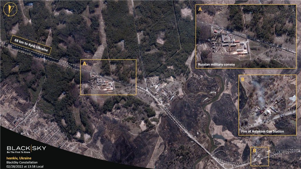
The commercial satellite industry have been playing a huge role in the Ukraine conflict, monitoring Russian troop movements or exact location of attacks and the extent of impact. And all this almost all in real time – thanks to the rise in number of earth observation satellites and an explosion in imagery.
ALSO READ: GeoInt, OSINT Comes Off Age For Near Real Time Coverage of Ukraine Conflict
Last month, Vice Adm. Robert Sharp, outgoing Director of the US National Geospatial Intelligence Agency (NGA), underlined the value of commercial satellite imagery and analytics that have been instrumental to the resistance put up by Ukraine against Russian aggression, and also to “shaping world views of the crisis”. In his keynote at GEOINT 2022 Symposium in April, he also said GEOINT is even being used “effectively to provide transparency, and counter Russian disinformation”.
Recent world events, including the war in Ukraine, have shined an unprecedented light on commercial geospatial intelligence and the value of programs such as EOCL that enable unclassified information sharing with U.S. allies and NATO partners, a statement from Maxar said.
However, even before the Ukraine crisis, the National Geospatial Intelligence Agency (NGA) has consistently been increasing its demand for commercial geospatial data and analytics, and had even drawn up a strategy to transition away from government analysts exploiting raw imagery to commercial analytic services that can quickly provide answers. In February the agency announced that it was building a commercial buying guide for its partners across the defense, intelligence and federal community, as the agency increasingly turns to commercial sources for imagery analysis and other geospatial intelligence.
Last year, the NGA awarded a USD 29-million contract to five players — BAE, Ball Aerospace, BlackSky, Continental Mapping Consultants, and Royce Geospatial Consultants Inc — that is designed to enable best of class analytic solutions for economic related GEOINT challenges.
Boost to commercial industry
The historic move is also expected to also help ensure long-term, continued support for the U.S. commercial remote sensing industry.
Rightfully, Planet called the EOCL as representing “the Federal government’s significant investment in and commitment to the commercial remote sensing sector and the capabilities and value it provides.”
“Planet has been proud to partner with the US government for many years, and the EOCL award is the next giant leap in our work together,” Robbie Schingler, Planet’s co-founder and Chief Strategy Officer, said in a statement. “We have long held the conviction that unclassified commercial satellite imagery not only equips the government with differentiated and innovative intelligence capabilities, but also increases transparency and accountability that advances global security, as well as trust between government and citizens. EOCL is this conviction realized.”
Similarly BlackSky called the award as demonstrating “the commitment of the U.S. Government to leverage the capabilities of next generation commercial providers in support of its most critical missions”.
“This contract is a pivotal moment in the expansion of the partnership between commercial space and the U.S. Government. We’re proud to be selected as a long-term trusted mission partner of the NRO,” said BlackSky CEO Brian O’Toole. “We will continue to enhance our Spectra AI platform and advance our satellite constellation in support of the NRO and our growing customer base around the world.”
Value of electro optical commercial layer (EOCL)
“Commercial imagery is a valuable tool for information sharing and decision making,” said Pete Muend, director of NRO’s commercial systems program office. “EOCL allows us to meet a larger number of customer requirements more quickly than ever before and dedicate national systems to the most challenging and sensitive missions.”
The electro-optical commercial layer includes a substantial increase in requirements for foundation data, intelligence points, and non-taskable data collection; shortwave infrared, nighttime, and non-earth imaging; and direct downlink to theater-based remote ground terminals—a vital capability for the military that has been successfully demonstrated in multiple exercises over the past year.
Maxar President and CEO Dan Jablonsky said, “This agreement provides a foundation for Maxar’s growth in the years ahead, as we continue through innovation and disciplined investment to meet our customers’ most demanding needs and generate long-term value for our shareholders. As always, we are committed to the mission success of our federal partners, and appreciate their longstanding trust in our capabilities, quality and reliability.”
The EOCL contract will transition the imagery acquisition requirements currently addressed by the EnhancedView Follow-On (EVFO) and its predecessor contracts, held by Maxar for over two decades. The five-year base and five one-year options, as well as its flexible contract structure, allows for increased technology innovation and capability development, demonstrating an important commitment by the U.S. Government to increase its utilization of commercial imagery, Maxar said.
The award to Planet Federal, a subsidiary of Planet, will enable the NRO and its partners, including those across the US national security community, to access the largest satellite operator’s high and medium resolution, daily satellite imagery for an initial period of up to five years, with options to extend the contract up to a total contract performance term of 10 years. In addition to data from Planet’s daily, medium resolution PlanetScope and high resolution SkySat satellites, users will soon have access to its next-generation, rapid revisit Pelican fleet that is expected to deliver up to 30cm resolution data. The contract also makes available our unequaled archive of over 2,000 images of every point on the Earth’s landmass, dating back to 2009.
BlackSky’s O’Toole said, “The contract value is significant, but if there were a bigger point, it would be that this award validates our strategy for a high revisit monitoring platform that provides dynamic monitoring of the most important and strategic locations in the world,”. “The BlackSky platform is a new and critical capability that the US government needs and has now selected to support their critical long-term mission requirements.”
By incorporating an advanced SaaS customer platform and combining a 14-satellite constellation, BlackSky offers one of the highest dawn-to-dusk revisit rates over the most critical regions in the world. BlackSky’s technology results in an average collection time of less than 90 minutes from the moment a customer places an order to product delivery.


