

Over the years illegal mining activities have caused severe blow to the environment and government agencies are trying their best to eradicate them.
The illegal mining sector has been a major cause of concern of the government agencies, policy makers and other organizations because of its involvement in national economies, impacts on society and environment. Over the years illegal mining activities have picked up pace and have caused irreversible damage to the environment like water contamination, depletion of natural resources, changing the course of water bodies, climate change, and ecological disruptions.
According to US Agency for International Development (USAID), at least 40 million people are involved in Artisanal and small-scale mining (ASM) around the world, which accounts for approximately 20% of the world’s production of gold, diamonds, tin and tantalum and 80% of colored gemstones.
Also Read: Esri UC: Technology meets vision to conserve Amazon forest
The Colombian concern
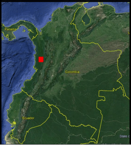
Over the years illegal mining activities have only flourished worldwide, and illegal gold mining in Latin America especially in Istmina, Colombia has become all the more worse. According to the Colombian government, it is the third most important driver of deforestation nationally, representing around 8 percent of all deforestation.
According to United Nations Office on Drugs and Crime (UNODC), the highest rate of illegal mining is in the Choco department and Istmina is a municipality located in the department of Choco. In Columbia 66% of alluvial gold mining is unregulated.
The authorities have been putting in efforts to monitor, detect and fight these illegal activities in real-time using optical satellite imagery but in recent years, they encountered a problem that during adverse weather conditions or improper illumination, the optical satellites imagery fail to produce correct images. These traditional sensors make it difficult to trace the illegal mining activities because the activities are mostly undertaken at night to avoid surveillance.
Recently Geosolutions in Eduador, a distributor of ENVI software, from L3Harris Geospatial and SAR data from Capella Space undertook a study to evaluate the use of high-resolution synthetic aperture radar (SAR) satellite data to accurately monitor and quantify the unlawful exploitation of gold in Istmina, Colombia. SAR satellite data provides the perfect solution for problems like availability of sunlight because it is capable of operating in both day and night, as well as it is able to see through the clouds and smokes. The texture analysis of SAR data magnifies its advantages over the traditional sensors by identifying different types of land coverage and highlighting elements of interest, better understand the phenomenon of illegal mining.
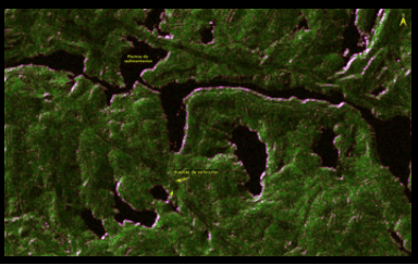
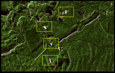
The visuals data collected of the same area between different time frames, clearly show the patches of deforestation areas, footprints of freight vehicles, infrastructures such as machinery and camps.
Also Read: Satellite imagery captures advances of massive forest fire in Turkey
What’s happening else where
A recent news report from Reuters revealed the extensive sand mining on Poyang Lake, China through satellite images, which highlighted huge areas of missing sand patches and change in the course of the river. Due to extensive sand mining, Poyang Lake has become the key flood outlet for the Yangtze River, which overflows during summer and causes damage to the crops. During winters the Lake water flows back to the river. According to NASA satellite data, the lake’s surface level reached an all-time high in summer 2020, just months after hitting a 60-year low during the winter of 2019.
Recently the Peruvian government’s Ministry of Environment (MNAM) was quoted as saying that by using NASA satellite data through SERVIR and Amazonia’s Radar Mining Monitoring Tool (RAMI), they are able to identify and monitor the potential areas of illegal mining, which helps them take timely action.
“The novelty of using synthetic aperture radar or SAR in a near-real time detection system in the Amazon is unique. Because radar penetrates through clouds, it makes it possible to generate and obtain consistent and frequent information on gold mining areas year-round,” Sidney Novoa, Peruvian non-profit group Conservación Amazónica (ACCA)’s Director for GIS & Technology Applied for Conservation, was quoted as saying.
There is a project between NASA and USAID are jointly working a project in use in Africa where the SERVIR- West Africa hub monitors similar cases of illegal gold mining and deforestations.

“This is a step towards protecting the Peruvian Amazon’s climate, clean water, and rich ecological heritage. This will also continue to help to advance scientific diplomacy between nations to address major global challenges. This project would not have been possible without experts from across South America, satellite data from our European colleagues, and knowledge sharing from similar efforts in West Africa, ” Sandra Cauffman, Deputy Director of NASA’s Earth Science Division, was quoted as saying.


