
Dr. Hrishikesh Samant
Sr. Associate Editor (Honorary)
[email protected]
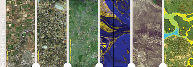
As spin-off of the surveillance technology used by defence establishments around the world, satellite-based earth observation (EO) has come a long way. Among the very first 'civilian' efforts mandated exclusively for EO was LandSat 1, formerly the Earth Resources Technology Satellite 1 (ERTS 1). Since the early 1970s, data from this satellite and its younger and better siblings is regarded as having served the longest span of consistently acquired visual records of our planetary surface. Efforts of a similar kind have also been successfully carried out by the IRS (Indian remote sensing satellites) series, albeit since the late 1980.
The question of whether technology is driving the applications or is it the other way round, has been mulled over in numerous debate circles. So what do the technology providers have to say? Kumar Navulur, Director, Next Gen Products, DigitalGlobe says, "For the last 30 years, it was technology feeding the application but the trend is reversing. Technology is still leading by a fraction but now we are seeing a lot more applications asking for specific spectral bands."
The availability of EO data in hard copy as well as digital formats has (according to some) resulted in a plethora of applications. Given the easy and free availability of temporal data, a whole lot of activities like analysing the process of change detection and monitoring of earth's surface have become 'doable' by anyone with a laptop. The Group on Earth Observations (GEO) and its Global Earth Observation System of Systems (GEOSS) programme, with their mandate on EO, have caused a paradigm change in the way a common man understands and appreciates the benefits of EO. This article examines some of the key applications of EO data.
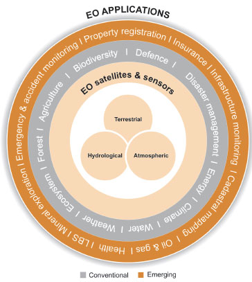
CONVENTIONAL APPLICATIONS
Disaster management and mitigation
As natural disasters know no bounds, the need for global coordination of information systems to address the entire cycle of disaster management and mitigation (DMM) is necessary. EO data, conventionally supplying the post disaster visuals, have been used very effectively in disaster assessment. Anil Kumar Sinha, Vice Chairman, Bihar State Disaster Management Authority, India, says, "At a global level, there is a very good understanding of EO technology and also good policy frameworks. Countries too are committed. What is needed is that the information derived from the analysis of EO systems reaches the actual workers on the ground." Today, EO data is supplemented by direct linkages to live data including global earthquake monitoring, ocean wave height monitoring, volcanic eruption, precipitation and snow and wind speed monitoring – leading to effective early warning systems.
Energy
The exploration of oil and gas, their extraction and production; electricity generation, transport and distribution, form only a part of the activities of the energy sector. The sector encompasses not only non-renewable resources, but also renewable resources such as solar, wind, biomass, and hydropower. The energy industry is heavily dependent on EO data. For example, weather data can form useful estimates for electricity supply and demand. EO data is important in the exploration, extraction and transport of the world's oil and gas reserves, several of which are located in remote and hostile territories. The data can also be used to build global resource maps for planning renewable energy projects.
Renewable energy systems have benefitted from EO data in not only their optimisation, but also in their integration with traditional energy supply systems. While renewable energy sources are environmentally a safer option than fossil fuels, they are highly susceptible to environmental changes, with their availability depending largely on the prevailing local weather conditions. Data on cloud cover and solar irradiance, along with wind speeds and directions, combined with environmental parameters such as land elevation and land cover, are vital elements in planning for the location and operation of renewable energy installations.
Climate
While the traditional means of data collection on land may give an indication of climate change at a local scale, it is only the amalgamation of such data from a large number of areas over a large time span, or the use of EO data on a global scale, that can truly give an indication of how the world's climate is responding to human expansion. For example, EO data makes it possible to track global vegetation trends over several years, examining its response to changing climate and also the impact that the increasing or decreasing vegetation cover has on climate.
Newer applications of EO data include studying seasurface temperatures in an attempt to correlate rising global temperatures and hurricane occurrences. The European Space Agency (ESA), through its satellite Envisat, is obtaining high accuracy data on sea surface temperatures, helping in prediction of not only the occurrence of a hurricane, but also its magnitude and intensity. Another important EO application is the tracking of forest fires, either natural, or man made through slash and burn agriculture or negligence. Of immediate interest in viewing the effects of global climate change is the measurement of the rate of loss of ice sheets. ESA's CryoSat mission is providing researchers with precise data on ice sheets in Greenland and Antarctica.
Water
That the world's fresh water reserves are slowly but surely depleting, has been proven by ground observations as well as EO data for gravity measurements. At regional and local levels, watershed and rainwater conservation practices have been drawing heavily on observations from EO satellites for fine tuning the water conservation practices which depend on terrain conditions, apart from the climatic zones.
For example, the Asian Water Cycle Initiative (AWCI), apart from utilising meteorological datasets, also utilises EO data for watershed characterisation and prioritisation. Crispino Lobo, Executive Director, Watershed Organisation Trust (WOTR), India says, "Today, it is a common practice to incorporate EO data in a GIS and the utility will further improve if sub-metre spatial resolution is made available. This is because water resource management is a people and community-centric activity where EO data becomes just one data input. But it needs effective integration with GPS along with inputs from the local community. Any application developed for water management also needs to have a 'people’ component."
Weather
The national meteorological departments around the world function more or less as standalone units, issuing short, medium and long term weather forecasts. The utilisation of EO data from meteorological satellites is probably the earliest usage of such form of data. Today, EO data is being utilised to "close critical gaps in meteorological and related ocean observations and enhance observational and information capabilities for the protection of life and property, especially with regard to highimpact events and more so in the developing world," states the mandate of GEO.
Ecosystem
Application of EO to ecosystem monitoring is invaluable, since through conventional means it is often impossible to monitor ecosystems on the large scales they demand. For example, EO data allows for easy monitoring of the harsh environs of the Arctic and the vast expanse of the Amazon rainforests.
Human impact, not only in the form of habitat destruction, but also in the form of invasive species introduction and over-harvesting, is the most common threat to several ecosystems. Conservation goals are often faced with the lack of quantitative data. One of the most important applications of EO data in this regard is ecosystem classification. EO data, which can give immense knowledge of an area's vegetation, together with ecological data, can help differentiate between different ecosystems housing different species.
Since the 1970s, infrared EO studies have been conducted on Arctic ice sheets to track the loss in ice sheet volume. In 2007, data indicated that the volume of the Arctic ice sheets had fallen to less than half the average volume determined since the inception of the study. This is not an encouraging piece of information on the only ecosystem that houses species such as the polar bear.
Forests and agriculture
Forests, with their immense importance to mankind, their susceptibility to climatic fluctuations and their constant threat from the ever-increasing demand for land, are in need of continual monitoring. The maintenance of forest resource records and their status over large areas and time spans allow an understanding of parameters such as total area, rate of loss of forested land, and indirectly, estimation of the magnitude of available forest resources. EO satellites provide a convenient and economic means of procuring such information, even over areas that are remote and inaccessible.
In 2009, Japan Aerospace Exploration Agency (JAXA)’s satellite Daichi imaged, in entirety, the world's forests at a resolution of 10 m, the first ever global forest imaging project at such a resolution. The aim of this project was to estimate the ability of the forest cover to absorb and store carbon dioxide, which has important implications towards global warming. On the other side of the globe, the Government of Brazil has, in partnership with the National Institute of Space Studies, monitored deforestation rates in the Amazon with the help of the CBERS satellites. They have estimated that the rate of deforestation in the Amazon has dropped to its lowest level in over two decades.
The immediate need for EO data in agriculture is apparent when one considers the rapid increase in global population and the consequent rise in demand for agricultural produce. Proper management and development of the world's agricultural resources require extensive information on agricultural set-ups, with respect to their types, location, kind of produce, quantity of produce and challenges faced. Applications of EO data in this field include crop assessment, crop-type classification, crop health assessment, agricultural landscape mapping, crop yield estimation and soil analysis.
Biodiversity
Continued economic growth and development are placing increasing stress on biodiversity the world over. EO data is a powerful tool for conservationists to monitor wildlife in areas that are remote or difficult to access, or simply too large for land-based reconnaissance.
One of the most recent and perhaps one of the most illustrative examples of the application of EO data in wildlife conservation is the discovery of rainforests on Mount Mabu in northern Mozambique. Later exploration of the virgin rainforests uncovered no fewer than three new species of butterflies, a previously undiscovered species of snake, seven threatened bird species and a rare orchid. According to Kew, UK-based Royal Botanic Gardens (RBG) botanist and expedition leader Jonathan Timberlake, "Even today we cannot say we know all of the world's key areas for biodiversity – there are still new ones to discover."
EMERGING APPLICATIONS
Health
The relationship between weather change and start of an epidemic is ancient wisdom based on centuries of observation. EO's ability to forecast weather has been used to attempt the possibility of predicting disease outbreak. The attempts at applying EO to improve health-related decision making need systems to model, collect and distribute coordinated epidemiological and environmental information. These have to be tagged with land use/land cover, population density, sanitation systems, water supply network and ancillary data that decide the vector, for predicting, monitoring and constructing risk maps and targeting interventions. Prof. Andy Morse, School of Environmental Science University of Liverpool, UK feels that the lack of ground truth in environmental observations, apart from the availability of meteorological, vegetation, soil, pollution and food availability data, is the cause of slow progress in applications of EO in the health sector. Ramesh Dhiman, Deputy Director, National Institute of Malaria Research, Indian Council of Medical Research observes that 'the application of EO for ecological risk mapping at national and international level, along with development of early warning tools using climate and EO data which is integrated with pollution data, is necessary for effective usage of EO data in the health sector."
Cadastral mapping
It is verifiably documented that land and property disputes cause more cases of homicide and violence annually in a populated country like India than the deaths due to war, strife and terrorism. To manage this, efforts have been initiated for cadastral mapping of the entire country. The backdrop of this exercise is EO data from high resolution satellites like Cartosat and WorldView. Kumar Navulur of DigitalGlobe says, "With QuickBird, the positional accuracy was 17 m off. That means one could make maps of 1:50,000 scale. WorldView 1 and 2 are just 3 m off, meaning one can make maps of 1:5000 or 1:8000 scale and we believe that that will come down to 1 m." He adds that EO data has the potential to be a significant source of base layer for mapping, which will allow for things like infrastructure development.
EO and location-based services
The impact of convergence between GPS and EO is best showcased by commercial vehicular navigation devices and the supporting vertical sectors of location-based services (LBS) that are proliferating from the marriage of these two technologies. Hervé Clauss, Director, Database Operations, TomTom informs that the company uses imagery as a reference for map creation/normalisation, which is the 'traditional' usage of such data for geometry, lanes, 3D and 2D city models, address verification, point of interest (POI) verification, new highway construction while it also uses 'fresh' imagery in 'reality check for change detection.'
EO is playing a decisive role in resources development and management, which is today strongly guided by ideologies of sustainability. Mineral exploration, including oil and gas, offers the prospect of 'missed opportunity – revisited' due to quantum jumps in the technology. V. Subramanyan, Professor in Earth Sciences, Indian Institute of Technology, Bombay, India, speaking in the context said, “EO in the context of mineral exploration offers a chance to rapidly, and if necessary, repeatedly survey large areas, in seeking the characteristic surface expressions or 'gossans' from more deeply hidden ore deposits. Apart from the discovery of new mineral deposits, EO data is also being effectively used in mapping and registering property, infrastructure monitoring, emergency monitoring and accident implications assessment along with environmental monitoring at mining and exploitation sites, says N. Sevastiyanov, General Designer, Gazprom Space Systems. Colin Grant, GSSC Core Member, Metocean Technical Authority, BP Exploration says, "As the oil and gas industry is moving to deeper waters and arctic areas, sea ice and iceberg monitoring and forecasting, oil spill monitoring and surveillance along with combinations of EO data with in-situ and modeled data to assist in forecast of key parameters – winds, waves, currents, water levels and sea ice, is being developed."
High resolution stereo imagery, radar, data and products like digital elevation models (DEMs) are being adopted as baseline data by insurance companies for calculation of vulnerability ratings. Procedures and algorithms for extracting bathymetry in near shore environments have been successfully demonstrated. The days of standalone imagery use are over. The proof lies in the increasing demand and supply of thematic layers being developed over popular virtual earths. Today, even the lay user of these applications demands value addition.
THE WRITING ON THE WALL
Answering 'where is it' is getting easier by the day as ground resolution improves. Answering 'what is it' every time is not possible. Automated change detection is still a technology which, if and when implemented successfully, will cause a boom and revival of applications which have been shelved for the lack of reliable and repetitive techniques. The raw product from the EO satellites and sensors was, is and will continue to be the base data for all earth surface, atmosphere, and, to some extent, sub-surface, monitoring, investigation and analysis.
Mathieu Benoit, Director, Earth Observation Group, VIASAT GeoTechnologies Inc. concludes, "The future belongs to high resolution (<50 cm) and cost is not much of an issue. Stereo capacity and access on demand along, with the capacity to produce information regardless of sensor type, will be the deciding factors." The days of very high resolution imageries in real colour are passé, but the information, intelligence and knowledge extracted from them and made available in multitude of themetic layers, along with value additions and guaranteed information updates, is the present and future. The ubiquity of EO is unfortunately not as easy to depict or state as that of geospatial technology.


